
blah blah blah
Mts. Tom and Field
Length: 7.4 miles out-and-back with loopDifficulty (click for info): Very Hard
Elevation Gain: 2950 feet
Rating (click for info): 8/10
Elevation: 4051' (Tom) and 4340' (Field)
Prominence: 351' (Tom) and 1701' (Field)
Driving Directions:
Trailhead and parking area are located at the Crawford Depot on Rt. 302, in Carroll, NH (summits are in Bethlehem). The Crawford Depot is 8.5 miles south of Rt. 3 and just south of the AMC Highland Center. Click here for a Google map.
About the Hike:
Mt. Field, the highest mountain in the Willey Range, has a mostly wooded summit with somewhat limited views to the east, west, and north. Since Mt. Avalon is nearby and provides much better views, Mt. Field is usually only climbed by hikers working on the 4000-footers. This popular loop combines Field with Mt. Tom, another Willey Range 4000-footer with limited views, and Mt. Avalon, allowing 4000-footer climbers to enjoy the view from Mt. Avalon while also necessarily visiting Tom and Field. Even though views are limited from these two mountains, what you can see from their viewpoints is rather impressive; therefore, this hike may also appeal to those who are willing to go the extra distance for a view into the Pemigewasset Wilderness.
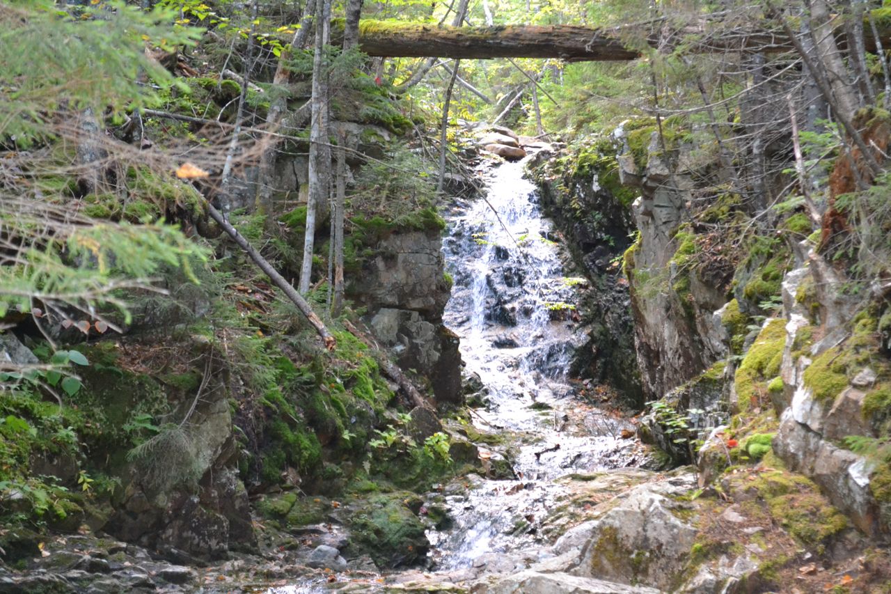
Cross the railroad tracks at the Crawford Depot and head out on the Avalon Trail. Pass Mt. Willard Trail on the left in 0.1 miles and cross ledgy Crawford Brook in another 0.1 miles. Soon, Cascade Loop turns left and leads back down to the brook. Follow this path and Beecher Cascade immediately comes into view. Here, the brook cascades down a narrow chute created by a rock crevice. A few hundred yards up is Pearl Cascade. Pearl is slightly shorter than Beecher, but is much wider. At this cascade, Crawford Brook fans out over a rock slab. After the loop rejoins the Avalon Trail, the path climbs moderately away from the brook. Soon, it passes a herd path on the left leading to a nice unnamed cascade. At 0.8 miles from the parking area, the trail recrosses Crawford Brook and climbs away on the other side. The trail soon flattens out for a while, then climbs to a junction half a mile from the last crossing. Bear right onto A-Z trail and climb briefly, then descend steeply to cross a wild, rocky stream. The trail swings to the right at the bottom, then climbs back up the bank to resume its moderate ascent across the hillside. In just over half a mile from here, it drops again to cross Crawford Brook near its source. After more moderate climbing, the trail steepens, beginning switchbacks with some rock stairs. In 0.4 miles from the last crossing, reach the Tom-Field col and turn right onto Mt. Tom Spur.
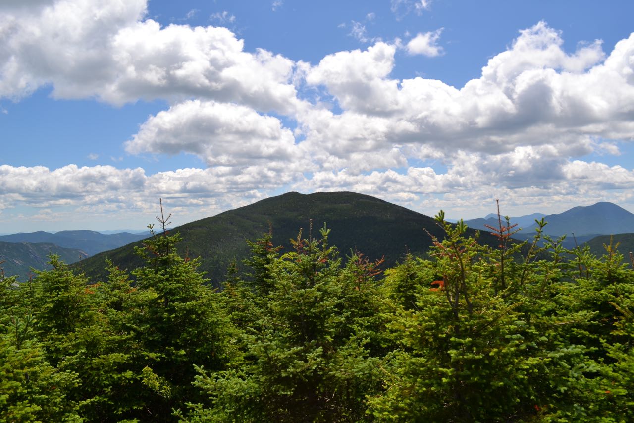
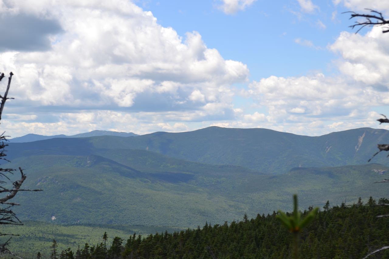
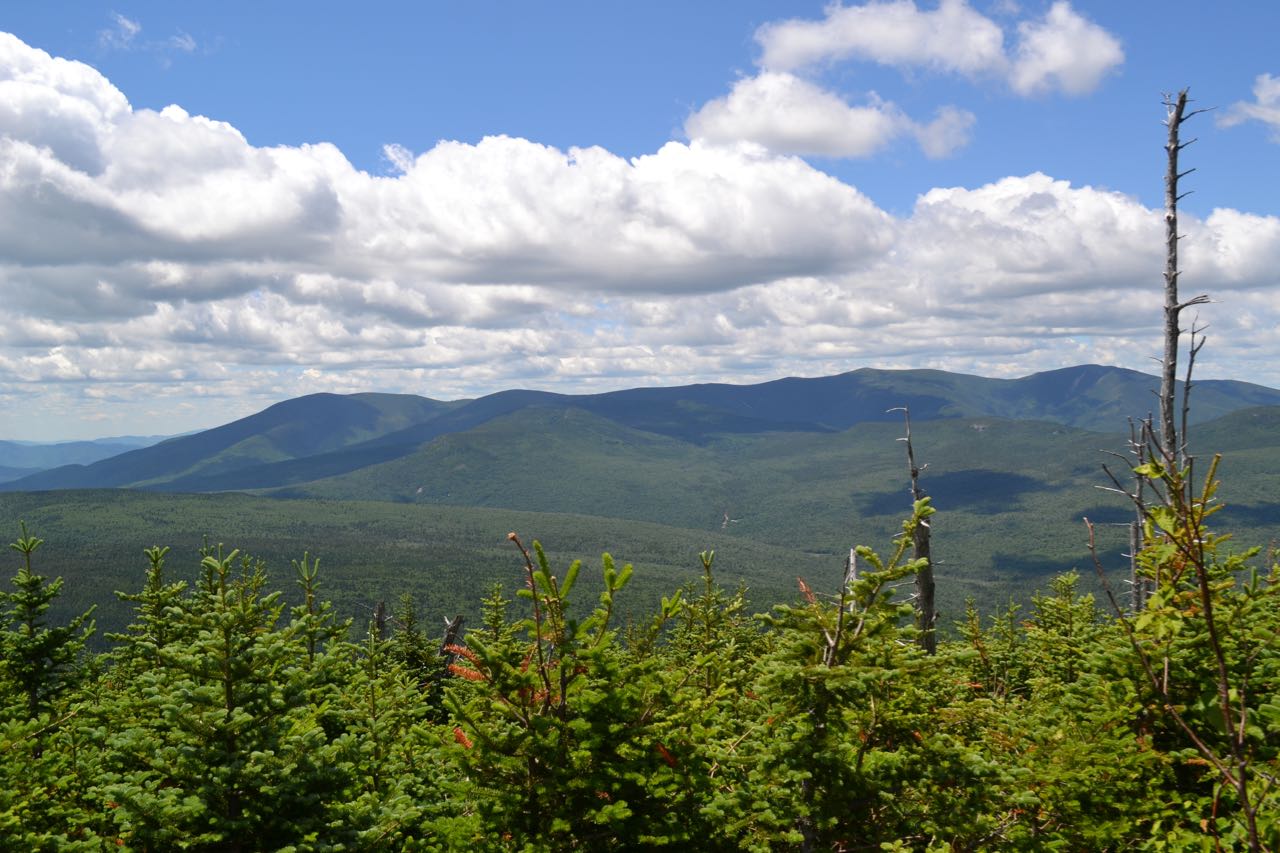
This trail winds up the ridge crest through a beautiful mossy fir forest for a mostly moderate 0.5 miles. After climbing log stairs, the trail forks in a small clearing. The right fork is a side path which leads to another clearing with views over the trees east to the Southern Presidentials, south to Mt. Field, and southwest into the Pemigewasset Wilderness. To the right of Mt. Field is Carrigain Notch and Mt. Carrigain, with Mts. Passaconaway and Whiteface beyond. Next over is Mt. Hancock, with Mt. Osceola behind and just to the right of its summit. To the right of Northwest Hancock and above Mt. Field's west peak and Whitewall Mountain is the long, bumpy Scar Ridge, which leads down to Loon Mountain and its ski trails. To the west is towering Mt. Bond. You will be able to see more in this direction from another viewpoint. Return to the main trail and continue a short distance over the flat summit plateau to the summit cairn. From here, the path continues to the western viewpoint. From this side, through a wide opening, you can see the entire Twin Range, as well as the Little River Mountains and the Zealand Valley. If you look closely, you will be able to see AMC's Zealand Falls Hut and Zealand Falls.
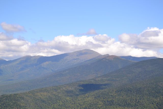
To continue on to Mt. Field, retrace your steps on the Mt. Tom Spur and continue on A-Z Trail. In less than 0.1 miles, turn left on to Willey Range Trail. The trail swings left onto the ridge top and ascends gradually through a dark conifer forest for 0.9 miles, passing limited views through the trees on the way. Near the top, the trail drops to the east side of the ridge to bypass the north summit. After passing the Avalon Trail on the left, it climbs steeply for 0.1 miles to the summit of Mt. Field. On the right side of the trail just before the summit, there is a view to the west over the Pemigewasset Wilderness. This view is similar to the one on Mt. Tom, but slightly more restricted. However, from here you can see further to the south, all the way to Scar Ridge and Loon Mountain. Since you are now higher, you can also see the Franconia Ridge peeking over the ridge between Mt. Guyot and South Twin Mountain. Looking back over the trail, you will see Mt. Tom, with many distant mountains in Vermont above. A spur path on the east side of the trail in the same place leads to a view over the Bretton Woods Valley. Cherry Mountain is to the right of Mt. Tom. The Pliny and Pilot Ranges rise above the rest of the Cherry-Dartmouth Range, further over. The Northern Presidentials appear through the trees on the far right.
To descend from Mt. Field, return to the last junction and head down the Avalon Trail. This trail descends easily at first, then more steeply as it follows Mt. Field's east ridge for 0.9 miles. The grade eases again at the bottom of this section, then the trail crosses a ledge with a view back up to the top. Just after this, Mt. Avalon Spur leads 0.1 miles to the right over one rock scramble to the minor summit of Mt. Avalon. From the sharp, rocky top, there is a wide directional view. The vista looks down Crawford Notch to the south, along the dramatic Webster Cliffs. Beyond Webster are Mts. Resolution and Crawford, with the Moat Range in the distance. Behind Webster, the impressive ridge of the Southern Presidentials leads up to Mt. Washington. From lowest to highest, the peaks of Mt. Jackson, Mt. Pierce, Mt. Eisenhower, and Mt. Monroe rise from the ridge. Above Mt. Pierce is Boott Spur, and to the left of Mt. Washington are Mts. Clay and Jefferson. Across Jefferson Notch from Mt. Jefferson is the Cherry-Dartmouth Range, as seen from Mt. Field. Directly below, you can see the AMC Highland Center and Saco Lake. To finish the loop, return to the Avalon Trail and continue down. Soon, the trail becomes steep and rocky and leads back to the junction with A-Z Trail in 0.5 miles.
Printable directions page